Hurricane Irene the next billion dollar disaster in 2011?


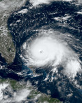
Waking up this morning, I discovered that Tropical Storm Irene had become Hurricane Irene. On top of that the storm itself has moved north of Puerto Rico missing the island of Hispaniola, which consists of Haiti and the Dominican Republic. Missing Hispaniola is great for Haiti, although they will still be impacted, but not so great for the Bahamas and the east coast of the United States. Now that the storm is not predicted to travel over the island of Hispaniola, where tropical systems can be slashed open by the high terrain weakening them, the storm now has time to spin up strength over the warm waters surrounding the Bahamas. This is bad because the warmer the water, the stronger a hurricane can get. As of this afternoon, many of the computer models predict that the path of Irene will run east of Florida, into the Carolinas and up the eastern seaboard, impacting the Interstate 95 region including Maryland, Delaware, New Jersey, Pennsylvania, New York (especially Long Island), Connecticut, Rhode Island and Massachusetts (especially Cape Cod and the Islands). This region is a highly dense population, with some areas that haven’t been impacted by a tropical system in close to eight to ten years (Isabel 2003, Floyd 1999). Further south where the storm will hit first, the South Carolina area, specifically Charleston, hasn’t been hit by a major hurricane (category 3 or higher) since category 4 Hurricane Hugo in 1989! To make matters worse the latest computer models have not only changed the path to include a larger area but because of the new path over warmer waters for longer, the strength is predicted to be close to or at category 3 strength by landfall. Category 3 strength is considered a major hurricane and can have sustained winds from 111 mph to 130.

So why do I think this storm has the possibility to be the next billion dollar disaster in the United States this year? Well it is a number of factors, which range over a number of regions, which will all be possibly impacted by this storm. First you have the damages caused to beach areas ahead of and behind the storm; this includes beach erosion, the fleeing of tourist and the added security measures taken to protect the public in the water due to rip currents and increased surf. Then you have the impacts of the storm itself. If it is to make landfall in the Carolina area as a category 3 not only will you have coastal damage but it will extend inland. The area which hasn’t seen a major hurricane in 20 years has since exploded with development. Buildings and infrastructure now sit in the damage zone adding to the cost of the storm. The mere fact that this storm could be as strong as a category 3, suggests heavy storm surge damage, inland flooding, and wind damage. This scenario can be very dangerous for the southeast coast, even to lives!
As the Irene moves inland up the I-95 corridor or up along the coast into New England, it may weaken but the damage will continue. Due to the recent circumstance impacting Philadelphia to Boston, Irene, even in a weaken state can do considerable damage. This is because of the extreme rains that have fallen over the New England cities. Many cities have surpassed their wettest month on record, or have come close to it. For example Central Park in New York City is closing in on a foot of rain already this month, according to weatherbug.com. This is over twice the average for the month and majority of it has fallen in the past 10 days! Philadelphia may have already broken their all time rainiest month record just last night, as of Saturday the city was a mere quarter of inch away from the record. This super soggy ground throughout the Mid-Atlantic and Northeast will not support additional tropical moisture but also will contribute to bringing down the wind threshold for falling trees. The soggy ground and the additional growth on vegetation from that rain has created a perfect scenario for tree fallings and power outages with even minimum tropical storm force winds, never mind hurricane force winds! Add together the flooding and the tree damage, that has its own ripple effects (power outages, damaged buildings, and damaged cars) over such a populated area and you may have another billion dollar disaster!
As with all weather predictions time will only tell! However awareness can go a long way in preparedness (check out my article on The Best Hurricane Information Sites to stay informed). What is known is that the ingredients are right for another billion dollar disaster and if that occurs, it will be the most billion dollar disasters in one year ever! The most important aspect to remember is Hurricane Irene may have an impact on millions of lives and when it comes down to it people need to be aware and prepared!